

|
|
The Twisted Climb - Darkness Descends
Book
2 of the award-winning Twisted Climb series
Where do you find the following: Little Current, Bridal Veil Falls, Chi-Cheemaun (pronounced Chee-Chee-Mawn), hawberries and the Iron Swing bridge?
Hint: The largest freshwater island in the world.
Another hint: It's on Lake Huron in Ontario, Canada.
Final hint: It's part of the North Channel, also known as the #1 sailing destination in the world.
Did you guess 'Manitoulin Island?' If you did, applause. You're correct.

 |
| Satellite image of Manitoulin Island |
Manitoulin Island, at almost 2,800 km² or about 1,070 sq miles in size, is the largest freshwater island in the world. The island itself has over 100 freshwater lakes, including Lake Manitou (104 km² or roughly 40 sq miles) which is the largest lake in a freshwater island in the world. And, according to Wikipedia, an island named Treasure Island in Lake Mindemoya is "the largest island in a lake on an island in a lake in the world." Now that's a tongue-twisting bit of trivia you probably didn't know.
The name 'Manitoulin' is the English translation of the Ottawa/Ojibwe name Manidoowaaling, meaning "cave of the spirit," as they believed the island housed a powerful spirit in an underwater cave. In 1951, Paleo-Indian artifacts were discovered in Sheguiandah, an area on the north-east shore, that dated back 10,000 - 30,000 B.C. It was believed that the ancestors of Native American Indians arrived from Asia in three waves, settling in Chile to the south, and north through what is now Mexico, the United States and Canada.
Manitoulin Island became part of the fur trade route begun by French and English explorers back in the early 17th century. Fur trappers and traders travelled the great lakes in canoes, trading goods for fur pelts. What is now referred to as the 'Beaver Wars' ensued, where the Iroquois battled for control of the fur trade in Manitoulin from the Anishinaabe people. On top of this conflict, explorers and traders brought an onslaught of European infectious diseases which proved catastrophic to the Native Indians. It is said that the Anishinaabe, in order to purify their lands, burned each settlement that they abandoned. For almost 150 years after that, the island had few inhabitants.
When the war of 1812 ended and the island was ceded to the British, native people from the Odawa, Ojibwe and Potawatomi tribes returned. In 1862, the government prepared what is known as the Manitoulin Island Treaty, allowing non-Native people the option to settle there. The Wikwemikong chief refused to sign the treaty and to this day, the Wikwemikong tribe maintains sovereign rights over the south-east section of the island and surrounding waters. As of 2016, the population on the island comprises European-Canadians (60%) and Aboriginal (40%).
There are only two ways to access the island: via land on a one-lane iron swing-bridge, or via water on a passenger ferry.
.jpg) |
| The swing bridge located at the town of Little Current, is the eastern waterway to the North Channel. Erected in 1913, the bridge is the only land access to the mainland. The bridge swings open on the hour, every hour, for 15 minutes, between dawn and dusk during spring, summer and fall. |
 |
| Bridal Veil Falls, is a popular tourist attraction near the town of
Kapawong, in central Manitoulin. It's 11 metres (35 feet) high and can be reached via a 5 km hiking trail. The concave contour below the waterfall allows tourists to walk behind it. Pictured above, you'll see me waving behind the falls, in a teal and white shirt. |
 |
| Bridal Veil Falls |
 |
| A Twisted Climb-type of full moon overlooking Manitoulin Island. |
 |
| Hawberries are abundant on the island and so are the jams and jellies. |
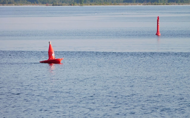 |
| There's a red, boat-shaped buoy in the channel at Little Current. The bow (forward section) of the little buoy shows you the direction of the current and the more the buoy tilts, the stronger the current. |

The Twisted Climb - Darkness Descends (Book 2)
voted BEST Young Adult Book 2018, Critters Readers Poll and Best YA Book FINALIST at The Word Guild, Canada
AND
The Twisted Climb,
voted BEST Young Adult Book 2016, P&E Readers Poll
Novels for teens, young adults and adults young at heart
Email: author.j.c.kavanagh@gmail.com
www.facebook.com/J.C.Kavanagh
www.amazon.com/author/jckavanagh
Twitter @JCKavanagh1 (Author J.C. Kavanagh)
Instagram @authorjckavanagh


Interestin island. Lots of information to explore
ReplyDeleteYes, interesting history and absolutely stunning in its natural beauty.
ReplyDeleteWhat a beautiful setting! Love the history of the place, too. Thanks for sharing.
ReplyDeleteWhat a great place to set a novel!
ReplyDeleteOoh yes. The land and waters 'speak.'
DeleteI want to GO there...while reading your books!
ReplyDeleteWhat a great idea! Thanks, Eileen :)
Delete